
Distance Formula On Map, Scale, Actual Distance
Loading...
Map scale is one of the most important elements in a map. With the scale description, you can find out the ratio between the distance on the map and the actual distance. To calculate it you need to use the distance formula on the map.
The scale on the map is not determined arbitrarily, but through calculations involving the distance on the map and the actual distance. Likewise, to get a certain number on the distance on the map and the actual distance, must go through a calculation process first.
List of contents
Definition and Function of Map Scale
In general, a map is known as a projection of the earth's surface in a flat plane or image. You can see a smaller portrait of the European continent on the map. This includes knowing the extent of the country and the cities in it.
In a map, usually found several terms or certain symbols that have meaning, one of which is the map scale. In each image in the atlas of a collection of maps, usually there is writing or a description of a certain scale. So, what exactly is the meaning of the map scale?
Map scale is a comparison of the size or distance between what is on the map and the actual distance above the earth's surface using the same unit. For example, if the map says the scale is 1:10,000, it means that 1 cm of distance on the map is equal to 10,000 cm of actual distance.
The function of this map scale is to calculate the distance of a certain location. This makes it possible to calculate the actual distance with only a map without the need to go to the actual location directly. Of course you can start applying the distance formula to the map.
Therefore, map scale is a very important component in the map-making process. Determination of the number must be based on accurate calculations so that it does not have a fatal impact on its use in the future. Calculating the map scale is using the map scale formula.
Once you know the ratio of the difference between the distances on the map and the real ones, you can project them for various purposes. Examples are used for development planning, regional planning and planning in other fields.
Read: Straight Line Equation
Types of Map Scale
Based on the Writing
The map scale itself has three types based on the writing on the map itself. Here are the three types of map scales;
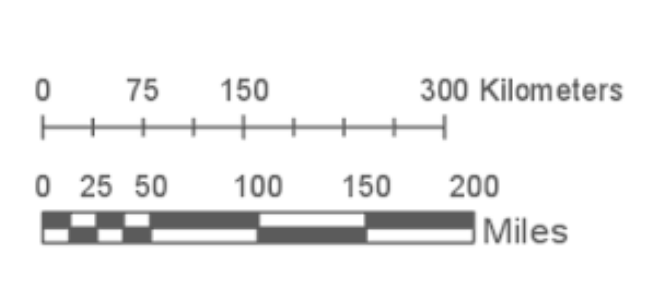
1. Graphic or Line map scale
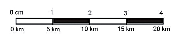
The scale of this type of map is usually shown in bar or line view. The line has markings and numbers to indicate the scale of the map. The advantage of this graphic scale is that when the map is enlarged or reduced, the bar image will also increase or decrease.
2. Number map scale

While the numeric map scale is a scale writing style that is probably the most frequent and easy to find. Usually in the format '1:actual distance', with units of 'cm'. Unlike the line scale, the number scale cannot change according to the enlargement or reduction of the image.
3. Map scale Letter or Verbal

Finally, there is a map scale where the ratio of the scale ratio is written. For example in a map it is written 'One cm on the map represents ten thousand cm in the real world'. In simple terms, this verbal scale is a description of the numerical map scale.
By Size
In addition, in Indonesia it is common for map scales to be divided into four types based on their size, namely;
1. Small Scale Map

Maps of this type range from more than 1:500,000, examples of which are used for national level planning purposes.
2. Medium Scale Map
For medium-scale maps it is usually 1:250,000 to 1:500,000. Usually used for planning purposes at the provincial level or certain national strategic areas.
3. Large Scale Map

While large-scale maps measure around 1: 5000 to 1: 250,000. This type of map is commonly used for planning at the city or district level, as well as for strategic areas at the provincial level.
4. Engineering Scale Map

Then, finally, there is a technical scale map which is more detailed and for special purposes. The sizes range from 1:100 to 1:500. This Engineering Map is commonly used for Building and Environmental Planning, Action Plans, and DED (Detailed Engineering Details).
Read: Cartesian Coordinates
Map Scale Formula
Advertisement
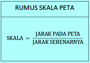
To determine the scale of the map, you need information about the distance on the map as well as the actual distance. Not only the distance formula on the map that must be understood, you also know and understand the formula for finding the value of distance or other ratios, namely:
Distance on map: Actual Distance
Both must be in the same unit
Example question: The distance between Jakarta and Tasikmalaya is 120 km, while the distance on the map is 10 cm, then what is the scale of the map?
Workmanship: the units of the actual distance and the distance on the map are different, so you have to equate them first. Convert km to cm.
Distance on map: 10 cm
Actual Distance: 175 km / 17,500,000 cm
The formula for finding the scale: the distance on the map divided by the original distance (actual distance)
: 10 cm: 17. 500000 cm
: 1: 175.000
: Then the scale of the map obtained in the image showing the City of Jakarta and Tasikmalaya is 1: 175,000
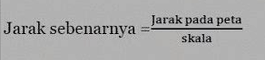
Distance Formula on Map

Then, what if all he asked was the distance on the map? You can find the answer by using the following formula;
Distance formula on map= Original scale on map x Original Distance (actual distance)
Example Problem: Determine the distance on the map between the cities of Surabaya and Bali which is 60 km, if the map scale is 1: 100,000
How it works: First, adjust the units between the scale and the actual distance in the question.
Actual Distance: 60 km / 6,000,000 cm
Map scale: 1:100,000
Formula to find distance on map: Scale on map x Original distance (actual distance)
: 1: 100,000 x 6,000,000 cm (6,000,000/100,000)
: 60 cm
: So, the distance on the map between the cities of Surabaya and Bali is 60 cm
Read: Math Vector
Real Distance Formula
Finally, what if the map scale and the distance on the map are known, while the actual distance is not? Here's the formula for finding the actual distance along with an example:
Real Distance Formula = Distance on map: map scale
Example problem: Calculate the actual distance between Makassar City and Palu, if the distance on the map shows 3 cm with a scale of 1: 12,000,000
How it works: Since the unit between the distance on the map and the scale is the same, which is cm, then you can directly divide it.
Distance on map: 3 cm
Map scale: 1: 12,000,000
The actual distance formula: the distance on the map times the scale on the map
: 3cm x 12,000,000/1
: 36,000,000 cm / 36 km
: Then the actual distance between Makassar City and Palu is 36 km
After practicing calculating the distance formula on the map above, you can see that the numbers in the map was determined very carefully based on structured calculations, not haphazard. Isn't it easy to calculate?
X CLOSE
Advertisements
ADVERTISEMENT
X CLOSE